UNESCO heritage
Tegallalang Rice Terraces Audio Guide (Sawah Terasering Tegallalang)
Bali's most famous green staircase is no stage set: it is a water-sharing machine that farmers, temples and offerings have kept running for about a thousand years.
- 60 min of audio
- Subak cultural landscape
Tegallalang is a district of the Gianyar regency, some 10 kilometres north of Ubud, known for its terraced rice fields. Those terraces are farmed with the subak, Bali's cooperative irrigation system, born around the 9th century and first cited in writing around the 11th century with the word kasuwakara. In 2012 UNESCO inscribed the cultural landscape of the subak on the World Heritage List.
Behind the postcard lies a network of faith: the water temples of the subak form a hierarchy that culminates in Pura Ulun Danu Batur, beside Lake Batur, regarded as the origin of all the springs and rivers of the island. Here rice is held to be a gift of the gods, and the fields are blessed before they are ploughed.
Highlights
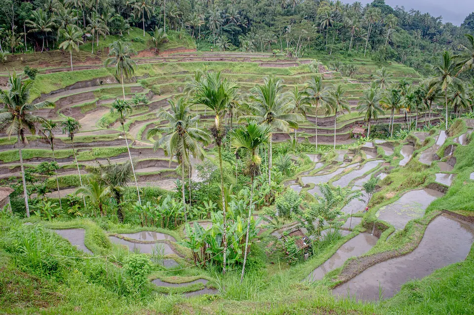
- Staircase of rice paddies — curved terraces climbing the west slope of the valley
- Irrigation channels — earth and stone ditches with wooden sluice gates that share the water among plots
- Field shrines — small bamboo or stone altars with daily offerings at the corners of the plots
- Subak — a cooperative irrigation system born around the 9th century and a World Heritage Site since 2012
- Coconut palms — silhouettes on the ridges that draw the classic postcard of Bali
About 10 kilometres north of Ubud, in the district of Tegallalang, an entire valley steps down in rice paddies: the Tegallalang Rice Terraces, in Indonesian Sawah Terasering Tegallalang, are the most famous terraces in Bali and probably the most photographed valley on the island. They belong to the Gianyar regency, which brings together Ubud, Tegallalang and Tampaksiring and is known as Gumi Seni, the Land of the Arts.
The history of the Tegallalang Rice Terraces is that of the subak, the cooperative system by which the water of Balinese rice fields is managed. It developed around the 9th century, and its first written mention, with the word kasuwakara, dates from around the 11th century. Each subak groups between about 50 and 400 farmers who share the water of a single source, and in 2019 the island had some 1,559 subaks over almost 20,000 hectares. On 6 July 2012 UNESCO inscribed on the World Heritage List the “Cultural Landscape of Bali Province: the Subak System as a Manifestation of the Tri Hita Karana Philosophy”, with 19,519.9 hectares protected.
What to see at the Tegallalang Rice Terraces is divided into three stops: the viewpoint beside the road, the valley floor among channels and terraces, and the northern viewpoint above the top of the terraces. Its architecture is not of carved stone but of earth and water: curved paddy steps, ditches with wooden sluice gates, small shrines at the corners of the plots and palms on the ridges. Followed with the audio guide, the landscape stops being a photo backdrop and reads as what it is: a collective work.
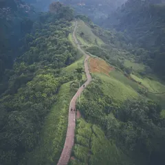
To the north, the subak system and the sacred water continue at the Tirta Empul Temple, beside the spring of Tampaksiring. Closer to Ubud, the Campuhan Ridge Walk offers another landscape of paddies and hills.
The postcard that hides an engineering feat
Roadside viewpoint
Summary of this stop
From the viewpoint beside the Tegallalang road, the view opens eastwards over the valley. The paddies descend in curved steps down the west slope, and on the ridges the coconut palms trace the silhouette of the classic Bali postcard.
What the postcard does not say is that this landscape was shaped by farmers. Tegallalang is part of the Gianyar regency, the Gumi Seni or Land of the Arts, and its terraces work thanks to the subak: cooperatives of between about 50 and 400 farmers who share the water of a single source. How that sharing is organised is what the narration reveals with the valley in front.
Down below, where the water is shared
In the paddies
Summary of this stop
On the valley floor, on the ridges that separate the terraces beside the stream, the subak can be seen up close. Small channels of earth and stone, with wooden sluice gates, divide the water among the plots, and at the corners of the fields appear bamboo or stone shrines with their daily offerings.
The system developed around the 9th century and its first written trace, the word kasuwakara, dates from around the 11th century. But the subak is not just hydraulics: it is part of temple culture. The water temples are ordered in a hierarchy that culminates in Pura Ulun Danu Batur, beside Lake Batur, held to be the origin of all the springs and rivers of the island. Rice is regarded as a gift of the gods, and water management follows the Tri Hita Karana, the three harmonies: parahyangan with the divine, pawongan among people and palemahan with nature.
It is a documented tradition that every subak has its own temple and its calendar of rites: the water is blessed before sowing, the field shrines receive offerings and the harvest is carried to the temple as a sign of gratitude. Here the fields are prayed over before they are ploughed, and the audio guide tells that cycle on the very ground where it happens.
The quiet end and the verdict of the world
Upper viewpoint
Summary of this stop
From the northern viewpoint, above the top of the terraces, the whole valley can be taken in. From here the scale of what the subak sustains becomes clear: in 2019 Bali had some 1,559 subaks covering almost 20,000 hectares.
On 6 July 2012 UNESCO inscribed on the World Heritage List the cultural landscape of the subak system as a manifestation of the Tri Hita Karana philosophy, with 19,519.9 hectares. The recognition does not reward merely a set of beautiful terraces, but a network of water temples headed by Pura Ulun Danu Batur and a way of understanding rice as a gift of the gods. What a visitor owes to those who work these fields is the question with which the narration closes the route.